Daytona Beach International Airport (DAB)
Orientation and Maps
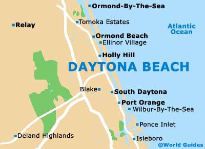
(Daytona Beach, Florida (FL), USA)
A city famous for its spring breaks, Daytona Beach is also known for its 'Bike Week', which takes place each March and attracts crowds of Harley Davidsons. Thriving on tourism, Daytona Beach is the perfect place for visitors who love motor racing. The Daytona International Speedway is located along the West International Speedway Boulevard and hosts the popular Daytona 500 each February, together with many other events throughout the calendar.
Those arriving by plane will find the Daytona Beach International Airport (DAB) located extremely close to the center and to the southwest of the main beachfront. The closest Amtrak train station is situated in nearby Deland, with regular buses linking the city. Local Votran buses operate around the Daytona Beach area and run from the Ponce Inlet, on the southern side of the city.
Daytona Beach International Airport (DAB) Maps: Important City Districts
The actual beach itself is fairly compact and it is possible to drive your car on the sands, for just a small charge. Swimming and surfing are particularly popular along Daytona Beach, although during the summer months, several areas may be blocked off when native sea turtles are nesting.
The downtown area has been renovated and tends to be more relaxed than the bustling beachfront, with plenty of places to shop, eat and drink. Brew pubs are especially plentiful in downtown Daytona Beach, standing close to many hotels and attractions. Highlights nearby include the Ponce de León Inlet Lighthouse and Museum, which is connected by buses and offers outstanding views from the observation deck, a climb of more than 200 stairs.
USA Map

Florida Map

Daytona Beach Map